

We’ve identified communities where you will be safe and welcome and where your vote will be a game-changer at the ballot box.Ohio: The Heart of it All
Living in northern Ohio, from its eastern industrial centers to its Lake Erie port city, offers a classic Midwestern experience with a strong community feel. The quality of life emphasizes a grounded, family-oriented lifestyle. Residents enjoy four distinct seasons, with cold, snowy winters and warm summers, supporting local outdoor activities, though less focused on wilderness adventures.
A key advantage is the affordable cost of living, particularly for housing, making homeownership widely accessible. The economy historically relied on heavy industry and manufacturing, but has diversified into healthcare, education, technology, and professional services, creating a stable job market. Educational opportunities are generally strong, with many well-regarded public school districts and state universities contributing to the region's appeal.
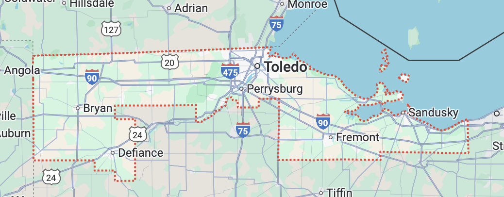
Ohio: Congressional District 9
Ohio: Congressional District 9
Ohio's 9th Congressional District could be exactly what you're looking for: an affordable home in a family-friendly environment with a diverse job market…all in a district where it is possible to have genuine political influence in one of the country's most competitive districts.
Much of this district includes areas designated Lower and Lowest Vulnerability on the US Climate Vulnerability Index.
COMMUNITY SNAPSHOTS

Perrysburg, Wood County
Perrysburg Livability Stats:
Suburban ● $$ ● Schools: A ● Crime: B ● Community Health: Average ● Nearby Airport
Perrysburg Homes for Sale and Rent
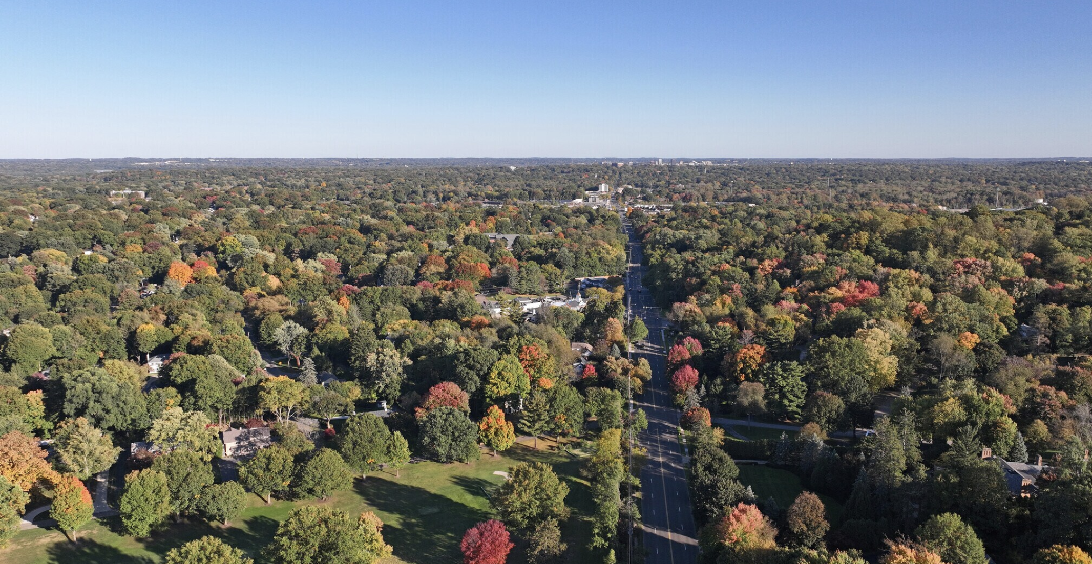
Perrysburg, Ohio, offers a highly desirable blend of small-town charm, rich history, and scenic beauty. Its dynamic economy is strongly supported by sectors like manufacturing (including major players like O-I Glass), healthcare (with Mercy Health—Perrysburg Hospital as a key facility), and educational services (including Owens Community College). The town's vibrant downtown features locally-owned shops and restaurants, complemented by a popular farmers market that fosters community connection. History enthusiasts will appreciate Fort Meigs, a significant War of 1812 site, and numerous historical markers throughout the area.
Education is a cornerstone of Perrysburg, with the Perrysburg Schools district consistently receiving "A+" ratings and recognized as a top-ranked district in the Toledo area for its academic excellence. For healthcare, residents have access to comprehensive services through Mercy Health—Perrysburg Hospital, a full-service community hospital providing emergency care, inpatient services, and specialized care.
Outdoor enthusiasts can enjoy the Maumee River for kayaking and fishing, along with extensive parks and trails for walking and biking. While Perrysburg offers a peaceful and friendly atmosphere, it's just a short drive from Toledo, allowing residents to enjoy the tranquility of a charming small town alongside the cultural and entertainment offerings of a larger city.
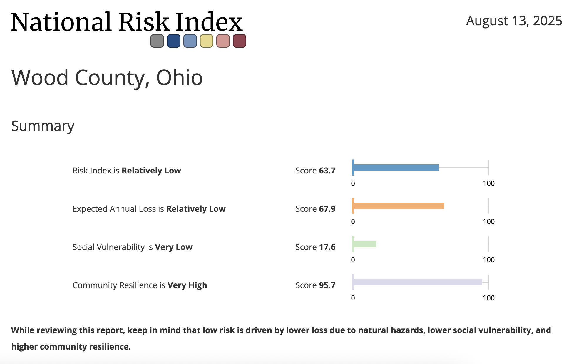
Perrysburg Climate Stats
Wood County ranks 80 out of 88 counties in Ohio for overall climate vulnerability. This places it in the 29th national vulnerability percentile, indicating a lower overall vulnerability.
Key Vulnerabilities:
The report identifies several key areas where Wood County has higher vulnerability:
Community Baseline - Mental Health & Deaths of Despair: This is a major area of concern, ranking in the 92nd national vulnerability percentile and 64th out of 88 counties in Ohio.
Community Baseline - Criteria Air Pollutants: The vulnerability from criteria air pollutants is high, ranking in the 88th national vulnerability percentile.
Climate Impacts - Precipitation: Vulnerability related to precipitation is high, ranking in the 74th national vulnerability percentile.
Climate Impacts - Temperature: The vulnerability related to temperature is high, ranking in the 63rd national vulnerability percentile.
Community Baseline - Pollution Sources: The county shows a high vulnerability from pollution sources, ranking in the 90th national vulnerability percentile.
Community Baseline - Environment: Environmental factors that pose a threat to community well-being show a high vulnerability, ranking in the 90th national vulnerability percentile.
Areas of Relative Resilience
The report also highlights several areas where the community shows lower vulnerability:
Community Baseline: The county ranks 79 out of 88 counties in Ohio for resilience to climate impacts. This places it in the 33rd national vulnerability percentile.
Community Baseline - Infrastructure: Essential structures, services, and resources that affect community resilience show very low vulnerability, ranking in the 17th national vulnerability percentile.
Community Baseline - Health: Factors reflecting the overall state of population health show low vulnerability, ranking in the 33rd national vulnerability percentile.
Climate Impacts - Social & Economic: The social and economic costs and impacts associated with climate change show low vulnerability, ranking in the 25th national vulnerability percentile.
Summary
Wood County has a lower overall climate vulnerability, ranking 80th out of 88 counties in Ohio.
The county's most significant vulnerabilities are related to community baseline factors such as mental health, air pollutants, and pollution sources, and climate impacts like precipitation and temperature.
Areas of resilience include the county's infrastructure, baseline health, and social & economic factors related to climate change impacts.
Pettisville, Fulton County

Pettisville Livability Stats
Rural ● $ ● Schools: A ● Crime: N/A ● Community Health: Average ● Nearby Airport
Pettisville Homes for Sale and Rent
Living in Pettisville, Ohio (population ~469) means embracing a peaceful, rural lifestyle with a strong sense of community. The town’s compact footprint—just under one square mile—makes it familiar and close-knit, ideal for families and those seeking quiet charm. The Pettisville Local School District serves as a community hub. With a modern PK–12 facility, small class sizes, STEAM-focused resources, and high levels of community support (including many open-enrollment students from neighboring districts), the schools earn high praise for academics and involvement.
The local economy is modest but stable. Residents enjoy a relatively high median household income—around $94,500 to $97,200—well above the national average Data. The unemployment rate ranges between approximately 4% and 5%—slightly higher than the national average yet still low. Many locals work in a mix of roles: office and administrative support, management, maintenance, and a surprisingly strong share in computer and mathematics fields—more so than in 95% of other places in the U.S. The jobs available locally tend to align with small town businesses—hardware stores, local supermarkets, service roles—and many commute to nearby towns for work.
Housing affordability is a major perk of Pettisville living. Median home values hover around $155,000—roughly half the national average—with high homeownership rates (above 88%) and affordable rent (around $880 monthly for a two-bedroom).
Residents frequently highlight how family-friendly the area feels. Reviews emphasize that it’s a supportive, rural community where residents rally around school events and local causes. Though amenities are limited—meaning a car is almost essential for errands—many value that tradeoff for the tranquility and affordability.
Pettisville Climate Stats

Fulton County ranks 82 out of 88 counties in Ohio for overall climate vulnerability. This places it in the 27th national vulnerability percentile, indicating a lower overall vulnerability.
Key Vulnerabilities:
The report identifies several key areas where Fulton County has higher vulnerability:
Precipitation: Vulnerability related to precipitation is very high, ranking in the 94th national vulnerability percentile.
Land Use: The vulnerability from land use is high, ranking in the 87th national vulnerability percentile.
Transportation: The vulnerability from transportation is high, ranking in the 81st national vulnerability percentile.
Extreme Events: Historical and projected extreme weather event occurrences show a high vulnerability, ranking in the 78th national vulnerability percentile.
Storms: The county shows a high vulnerability to storms, ranking in the 77th national vulnerability percentile.
Areas of Relative Resilience
The report also highlights several areas where the community shows lower vulnerability:
Community Baseline: The county ranks 72 out of 88 counties in Ohio for resilience to climate impacts, placing it in the 20th national vulnerability percentile.
Health (Community Baseline): Factors reflecting the overall state of population health show low vulnerability, ranking in the 13th national vulnerability percentile.
Infrastructure: Essential structures, services, and resources that affect community resilience show very low vulnerability, ranking in the 7th national vulnerability percentile.
Social & Economic (Climate Impacts): The social and economic costs and impacts associated with climate change also show low vulnerability, ranking in the 13th national vulnerability percentile.
Health (Climate Impacts): Expected changes in community health resulting from a warming climate show low vulnerability, ranking in the 32nd national vulnerability percentile.
Summary
Fulton County has a lower overall climate vulnerability, ranking 82nd out of 88 counties in Ohio.
The county's most significant vulnerabilities are related to climate impacts such as precipitation and extreme events, as well as community baseline factors like land use and transportation.
Areas of resilience include the county's infrastructure, baseline health, and social & economic factors.

Ottawa Hills, Lucas County
Ottawa Hills Livability Stats:
Suburban ● $$ ● Schools: A ● Crime: B ● Community Health: Average ● Nearby Airport
Ottawa Hills Homes for Sale and Rent
Ottawa Hills offers a taste of suburban serenity bordering the bustling city of Toledo, making it an affluent community that caters to those seeking a comfortable and convenient lifestyle. Its tree-lined streets and manicured lawns are all within a short distance of the cultural and professional opportunities Toledo provides. The local economy is robust, with major employment sectors including healthcare and social assistance, educational services, and professional, scientific, and technical services.
For families, Ottawa Hills is a haven. The Ottawa Hills Local School District ranks highly among Ohio's best school districts, offering a strong educational foundation with high proficiency rates in math and reading. Numerous parks and green spaces provide ample opportunities for outdoor play and exploration, with the Ottawa Hills Community Pool and the Toledo Metroparks offering extensive recreational options.
Beyond the focus on families, Ottawa Hills boasts a hidden charm. Quaint cafes and restaurants line the streets, offering a chance to unwind and savor delicious food. Unique shops cater to discerning tastes, while local art galleries showcase the creative spirit of the community. The nearby Toledo Museum of Art offers a world-class collection for art enthusiasts, while sites like the Toledo Botanical Garden and the Toledo Zoo provide enriching experiences. While Ottawa Hills itself might not have a vibrant nightlife, residents enjoy the best of both worlds, with Downtown Toledo's theaters, restaurants, and entertainment options just a short drive away.
Ottawa Hills Climate Stats

Ottawa Hills is in the 23rd national vulnerability percentile, indicating a lower overall vulnerability.
Key Vulnerabilities:
The report identifies several key areas where this tract and the surrounding county have higher vulnerability:
Tornado: The risk index rating for tornadoes in Lucas County is "Relatively High" with a score of 96.3.
Strong Wind: The risk index rating for strong winds in Lucas County is "Relatively High" with a score of 92.7.
Winter Weather: The risk index rating for winter weather in Lucas County is "Relatively High" with a score of 89.3.
Heat Wave: The risk index rating for heat waves in Lucas County is "Relatively Moderate" with a score of 82.6.
Riverine Flooding: The risk index rating for riverine flooding in Lucas County is "Relatively Moderate" with a score of 89.4.
Pollution Sources: The Toledo tract has a vulnerability related to pollution sources, but specific numerical rankings are not provided in this summary document.
Mental Health & Deaths of Despair: This is a key area of concern for the tract, but specific numerical rankings are not provided in the report.
Areas of Relative Resilience
The report also highlights several areas where the community shows lower vulnerability:
Community Resilience: The community resilience in Lucas County is "Very High" with a score of 95.9.
Health (Community Baseline): Factors reflecting the overall state of population health are noted as areas of relative resilience for the tract, but specific numerical rankings are not provided.
Infrastructure: The county's infrastructure is a significant strength, but specific numerical rankings are not provided for the tract.
Social & Economic (Climate Impacts): The social and economic costs and impacts associated with climate change are noted as areas of relative resilience for the tract, but specific numerical rankings are not provided.
Summary
This community outside of Toledo, Ohio, has a lower overall climate vulnerability, ranking in the 23rd national vulnerability percentile.
The most significant vulnerabilities for the surrounding Lucas County area are related to climate impacts such as tornadoes, strong winds, and winter weather. Other key vulnerabilities for the specific tract are pollution sources, mental health, and precipitation.
Areas of resilience include the county's community resilience, infrastructure, and social & economic factors.
Maumee, Lucas County

Maumee Livability Stats:
Suburban ● $ ● Schools: A ● Crime: B ● Community Health: Average ● Nearby Airport
Maumee Homes for Sale and Rent
Maumee, Ohio, is a welcoming Toledo suburb along the Maumee River, known for its historic uptown district, walkable streets, and community-oriented feel. With about 14,000 residents, it blends small-town charm with easy access to Toledo’s amenities. The cost of living is roughly 22% below the national average, and housing remains affordable compared to many U.S. markets, with typical home values around $280,000. The local economy is strong, boasting a low 2.2% unemployment rate, median household income of about $71,000, and a mix of jobs in manufacturing, healthcare, education, and professional services—plus many commuting options into Toledo.
Residents enjoy parks, cultural events, and local shops, while larger employers like General Motors, Owens-Illinois, and Dana Corporation provide stability. Outdoor lovers can kayak or fish along the Maumee River, explore the scenic Towpath Trail, or visit Side Cut Metropark, while The Shops at Fallen Timbers offer dining, shopping, and entertainment. The city’s recent efforts to make downtown more pedestrian-friendly have enhanced its appeal, though driving is still the norm. Overall, Maumee offers a safe, family-friendly environment with a solid job market, affordable homes, and a balance of small-town warmth and metropolitan access.
Maumee Climate Stats

Ottawa Hills is in the 23rd national vulnerability percentile, indicating a lower overall vulnerability.
Key Vulnerabilities:
The report identifies several key areas where this tract and the surrounding county have higher vulnerability:
Tornado: The risk index rating for tornadoes in Lucas County is "Relatively High" with a score of 96.3.
Strong Wind: The risk index rating for strong winds in Lucas County is "Relatively High" with a score of 92.7.
Winter Weather: The risk index rating for winter weather in Lucas County is "Relatively High" with a score of 89.3.
Heat Wave: The risk index rating for heat waves in Lucas County is "Relatively Moderate" with a score of 82.6.
Riverine Flooding: The risk index rating for riverine flooding in Lucas County is "Relatively Moderate" with a score of 89.4.
Pollution Sources: The Toledo tract has a vulnerability related to pollution sources, but specific numerical rankings are not provided in this summary document.
Mental Health & Deaths of Despair: This is a key area of concern for the tract, but specific numerical rankings are not provided in the report.
Areas of Relative Resilience
The report also highlights several areas where the community shows lower vulnerability:
Community Resilience: The community resilience in Lucas County is "Very High" with a score of 95.9.
Health (Community Baseline): Factors reflecting the overall state of population health are noted as areas of relative resilience for the tract, but specific numerical rankings are not provided.
Infrastructure: The county's infrastructure is a significant strength, but specific numerical rankings are not provided for the tract.
Social & Economic (Climate Impacts): The social and economic costs and impacts associated with climate change are noted as areas of relative resilience for the tract, but specific numerical rankings are not provided.
Summary
This community outside of Toledo, Ohio, has a lower overall climate vulnerability, ranking in the 23rd national vulnerability percentile.
The most significant vulnerabilities for the surrounding Lucas County area are related to climate impacts such as tornadoes, strong winds, and winter weather. Other key vulnerabilities for the specific tract are pollution sources, mental health, and precipitation.
Areas of resilience include the county's community resilience, infrastructure, and social & economic factors.

Ohio: Congressional District 13
Ohio: Congressional District 13
Northeast Ohio offers a diverse lifestyle, whether you're seeking city vibrancy or the peacefulness of historic towns and rural landscapes, all benefiting from affordable living costs and a strong job market. Major cities like Akron provide a rich arts and culture scene, featuring numerous museums, theaters, and a burgeoning craft brewery industry. The regional economy is robust, with significant employment in healthcare, manufacturing, and logistics, alongside promising growth in the tech sector.
Abortion is constitutionally protected in Ohio - but there are a number of rules and regulations that may restrict access and make accessing reproductive healthcare more complicated.
And, this is a district where it is possible to have genuine political influence in one of the country's most competitive districts.
Much of this district includes areas designated Lower and Lowest Vulnerability on the US Climate Vulnerability Index.
COMMUNITY SNAPSHOTS
Reminderville, Summit County
Reminderville Livability Stats:
Suburban ● $$ ● Schools: A ● Crime: A ● Community Health: Average ● Nearby Airport
Reminderville Homes for Sale and Rent
Reminderville is truly a hidden gem, perfectly blending small-town charm with convenient access to major urban centers. Tucked between Aurora and Twinsburg, this friendly village offers a peaceful, rural-suburban vibe while remaining just a short drive from Akron and Cleveland. The local economy in Reminderville is supported by small businesses, retail services, and professional offices that cater to its residents. Many locals also commute to Akron or Cleveland, tapping into those cities' diverse job markets in sectors like healthcare, manufacturing, technology, and education, ensuring a wide array of employment opportunities.
For families, Reminderville checks all the boxes, especially with its top-rated schools. Students in Reminderville primarily attend the highly-regarded Twinsburg City School District, known for its strong academic programs, dedicated teachers, and extensive extracurricular activities. For healthcare, residents have convenient access to local clinics and urgent care centers. Comprehensive medical services, including high-quality reproductive healthcare options, are readily available through the extensive networks of major hospitals in nearby Twinsburg (such as Cleveland Clinic Twinsburg Family Health & Surgery Center), Akron (like Summa Health System and Cleveland Clinic Akron General), and Cleveland (including University Hospitals Cleveland Medical Center and Cleveland Clinic Main Campus).
What truly makes Reminderville special is its strong sense of community. There's plenty of green space for outdoor fun, plus great restaurants and shopping just a few minutes away. With safe streets, well-kept neighborhoods, and a laid-back, friendly atmosphere, Reminderville is the kind of place where life feels easy, comfortable, and just right, making it a welcoming community for all.

Reminderville Climate Stats

Summit County ranks 59 out of 88 counties in Ohio for overall climate vulnerability. This places it in the 43rd national vulnerability percentile, indicating a lower overall vulnerability.
Key Vulnerabilities:
The report identifies several key areas where Summit County has higher vulnerability:
Climate Impacts: Elevated vulnerability in several climate-impact drivers, including Precipitation (97th national percentile) and Infectious Diseases (91st). Air pollution–related deaths (93rd) and Exposures & Risks (94th) are also high.
Extreme Events (by hazard): FEMA’s National Risk Index shows Very High risk scores for Winter Weather (97.7) and Relatively High for Hail (98.7), Riverine Flooding (95.0), and Tornado (90.2).
Pollution Sources: Very high baseline environmental burden, ranking 6th in Ohio and 97th national percentile.
Mental Health & Deaths of Despair: High vulnerability (80th national percentile).
Areas of Relative Resilience
The report also highlights several areas where the community shows lower vulnerability:
Community Baseline: Overall baseline conditions rank 49 out of 88 in Ohio, with an average level (54th national vulnerability percentile).
Infrastructure (Community Baseline): Low vulnerability, 20th national percentile, indicating relatively strong essential structures and services.
Climate Impacts (overall): Lower vulnerability, 22nd national vulnerability percentile; Extreme Events specifically are 31st percentile. Social & Economic (Climate Impacts) is particularly low at the 11th percentile.
Community Resilience (FEMA NRI): Relatively High resilience (score 79.8), with only 20% of U.S. counties higher—an asset for preparedness and recovery.
Summary
Summit County has a relatively low overall climate vulnerability. Primary vulnerabilities include heavy precipitation-related impacts, pollution exposure, and winter weather, hail, riverine flooding, and tornado risk per FEMA’s hazard rankings.
Areas of resilience include strong infrastructure, relatively high community resilience, and lower vulnerability across several climate-impact cost categories, which together mitigate overall risk.
Fairlawn, Summit County
Fairlawn Livability Stats:
Suburban ● $$ ● Schools: A ● Crime: A ● Community Health: Average ● Nearby Airport
Fairlawn Homes for Sale and Rent
Fairlawn offers a perfect blend of suburban comfort and city convenience, nestled just outside Akron. This welcoming community features beautiful neighborhoods, ample parks, and green spaces, fostering an easygoing lifestyle. Its economy is robust, with significant employment in educational services, retail trade, and finance & insurance, indicating a strong local business presence. Major employers in the broader region include healthcare systems, manufacturing companies like Continental Industry, and various professional services, offering diverse job opportunities for residents.
The Copley-Fairlawn City School District, serving the area, is highly-rated (ranking in the top 11% of Ohio schools) and provides an excellent educational foundation for children. For healthcare, residents have convenient access to local facilities such as UH Fairlawn Health Center, which offers a range of primary and specialty care, laboratory, and diagnostic imaging services. Additionally, major hospitals like Cleveland Clinic Akron General and Summa Health System are just a short drive away, ensuring comprehensive and high-quality medical care.
Fairlawn cultivates a strong sense of community through local events, excellent restaurants, and diverse shops. Its safety, well-kept streets, and friendly neighbors make it an attractive spot for families, young professionals, and retirees alike. With quick access to major highways, commuting to Cleveland or other nearby cities is a breeze, allowing residents to enjoy a peaceful yet convenient lifestyle.
Fairlawn Climate Stats

Summit County ranks 59 out of 88 counties in Ohio for overall climate vulnerability. This places it in the 43rd national vulnerability percentile, indicating a lower overall vulnerability.
Key Vulnerabilities:
The report identifies several key areas where Summit County has higher vulnerability:
Climate Impacts: Elevated vulnerability in several climate-impact drivers, including Precipitation (97th national percentile) and Infectious Diseases (91st). Air pollution–related deaths (93rd) and Exposures & Risks (94th) are also high.
Extreme Events (by hazard): FEMA’s National Risk Index shows Very High risk scores for Winter Weather (97.7) and Relatively High for Hail (98.7), Riverine Flooding (95.0), and Tornado (90.2).
Pollution Sources: Very high baseline environmental burden, ranking 6th in Ohio and 97th national percentile.
Mental Health & Deaths of Despair: High vulnerability (80th national percentile).
Areas of Relative Resilience
The report also highlights several areas where the community shows lower vulnerability:
Community Baseline: Overall baseline conditions rank 49 out of 88 in Ohio, with an average level (54th national vulnerability percentile).
Infrastructure (Community Baseline): Low vulnerability, 20th national percentile, indicating relatively strong essential structures and services.
Climate Impacts (overall): Lower vulnerability, 22nd national vulnerability percentile; Extreme Events specifically are 31st percentile. Social & Economic (Climate Impacts) is particularly low at the 11th percentile.
Community Resilience (FEMA NRI): Relatively High resilience (score 79.8), with only 20% of U.S. counties higher—an asset for preparedness and recovery.
Summary
Summit County has a relatively low overall climate vulnerability. Primary vulnerabilities include heavy precipitation-related impacts, pollution exposure, and winter weather, hail, riverine flooding, and tornado risk per FEMA’s hazard rankings.
Areas of resilience include strong infrastructure, relatively high community resilience, and lower vulnerability across several climate-impact cost categories, which together mitigate overall risk.

Uniontown, Stark County
Uniontown Livability Stats:
Suburban/Rural ● $ ● Schools: A ● Crime: A ● Community Health: Average ● Nearby Airport
Uniontown Homes for Sale and Rent
Uniontown, Ohio, is a quiet and welcoming community in Stark County that blends small-town charm with easy access to nearby cities like Akron and Canton. With just over 7,000 residents, it offers a slower pace of life where neighbors tend to know each other and streets remain calm and safe. The area is largely residential, with tree-lined neighborhoods, locally owned shops, and a few family-run restaurants and cafes that give it a friendly, close-knit feel. Residents often mention the strong sense of community and the pride people take in maintaining their homes and yards.
The cost of living in Uniontown is significantly lower than the national average, making it an affordable choice for families and retirees. Housing is reasonably priced, with a median home value around $240,000 and property taxes that are modest compared to many other parts of the country. Most residents own their homes, and the local economy benefits from a median household income close to $100,000, which provides a comfortable standard of living. Daily life is generally relaxed, with errands and essentials just a short drive away.
Uniontown’s location offers both tranquility and convenience. While the town itself maintains a laid-back atmosphere, major shopping, dining, and cultural activities are just minutes away in surrounding communities. Outdoor recreation is easy to find, with nearby parks, trails, and the Tuscarawas River providing opportunities for walking, cycling, and fishing. The town doesn’t have much in the way of nightlife, but for many residents, the trade-off is worth it for the peace and quiet. Living in Uniontown means enjoying the comforts of a stable, neighborly community while still staying connected to the resources of a larger metro area.
Uniontown Climate Stats

Stark County ranks 51 out of 88 counties in Ohio for overall climate vulnerability. This places it in the 47th national vulnerability percentile, indicating an average overall vulnerability.
Key Vulnerabilities:
The report identifies several key areas where Stark County has higher vulnerability:
Criteria Air Pollutants – Extremely high vulnerability, ranking 1st in Ohio and in the 99th national vulnerability percentile.
Exposures & Risks – Very high vulnerability, ranking 4th in Ohio and 95th nationally.
Infectious Diseases – Very high vulnerability, ranking 10th in Ohio and 95th nationally.
Social Stressors (Climate Impacts) – Very high vulnerability, ranking 6th in Ohio and 97th nationally.
Environment (Community Baseline) – High vulnerability, 93rd national percentile.
Areas of Relative Resilience
The report also highlights several areas where the community shows lower vulnerability:
Infrastructure (Community Baseline) – Low vulnerability, 14th national percentile, indicating strong essential services and structures.
Climate Impacts (overall) – Lower vulnerability, 28th national percentile, with Extreme Events at 32nd percentile and Social & Economic (Climate Impacts) at 23rd percentile.
Social & Economic (Community Baseline) – Lower vulnerability, 42nd national percentile, suggesting moderate resilience in socioeconomic factors.
Summary
Stark County’s overall climate vulnerability is moderate, but it faces notable risks from air pollution, environmental exposures, infectious diseases, and climate-related social stressors. These issues place the county near the top nationally in several high-impact categories.
However, strong infrastructure, relatively lower vulnerability to extreme weather events, and moderate socioeconomic resilience provide important buffers against climate impacts.
North Canton, Stark County

North Canton Livability Stats:
Suburban ● $$ ● Schools: A ● Crime: B ● Community Health: Average ● Nearby Airport ● Walkability
North Canton Homes for Sale and Rent
Living in North Canton, Ohio offers a blend of suburban comfort, affordability, and community focus—perfect for those seeking stability with convenient access to larger cities. It's home to around 17,800 residents and earns praise as one of the best places to live in Ohio, thanks to its dense suburban feel, well-kept parks, and a range of coffee shops and neighborhood amenities.
One of North Canton's strongest draws is its cost of living. Overall expenses are roughly 21% lower than the national average, with housing costs particularly competitive—median home values fall between $194K to $232K, depending on the source. It's an attractive market for both buyers and long-term investors, with one-year home value appreciation nearing 11%. Renters benefit too, with median two-bedroom rents of around $980 per month, well below national norms.
Residents consistently highlight the area's strong sense of safety and community. Driving through town you'll feel the welcoming atmosphere: neighbors know each other, streets are quiet, and public spaces are well cared for. As one reviewer put it, Families appreciate the local schools, and younger residents praise the parks and bike trails as standout features.
North Canton leans very car-dependent. Sidewalks and public transit infrastructure are sparse, and biking or walking to destinations—even from nearby areas—can feel impractical. In addition, though the community is welcoming,
Highlights like annual events—the Main Street Festival, Winterfest, and the 720 Market—bring residents together, lending vibrancy to the season and helping offset quieter stretches of life
North Canton Climate Stats
Stark County ranks 51 out of 88 counties in Ohio for overall climate vulnerability. This places it in the 47th national vulnerability percentile, indicating an average overall vulnerability.
Key Vulnerabilities:
The report identifies several key areas where Stark County has higher vulnerability:
Criteria Air Pollutants – Extremely high vulnerability, ranking 1st in Ohio and in the 99th national vulnerability percentile.
Exposures & Risks – Very high vulnerability, ranking 4th in Ohio and 95th nationally.
Infectious Diseases – Very high vulnerability, ranking 10th in Ohio and 95th nationally.
Social Stressors (Climate Impacts) – Very high vulnerability, ranking 6th in Ohio and 97th nationally.
Environment (Community Baseline) – High vulnerability, 93rd national percentile.
Areas of Relative Resilience
The report also highlights several areas where the community shows lower vulnerability:
Infrastructure (Community Baseline) – Low vulnerability, 14th national percentile, indicating strong essential services and structures.
Climate Impacts (overall) – Lower vulnerability, 28th national percentile, with Extreme Events at 32nd percentile and Social & Economic (Climate Impacts) at 23rd percentile.
Social & Economic (Community Baseline) – Lower vulnerability, 42nd national percentile, suggesting moderate resilience in socioeconomic factors.
Summary
Stark County’s overall climate vulnerability is moderate, but it faces notable risks from air pollution, environmental exposures, infectious diseases, and climate-related social stressors. These issues place the county near the top nationally in several high-impact categories.
However, strong infrastructure, relatively lower vulnerability to extreme weather events, and moderate socioeconomic resilience provide important buffers against climate impacts.
We have put together a comprehensive guide for Ohio that includes:
Modeling data about climate risks, vulnerabilities, and strengths;
Political Context and Competitiveness;
Community Overview of the Region and Neighborhoods;
Economic Opportunity and Cost of Living; diversified economy with growing opportunities;
Schools and Education;
Civic Engagement Opportunities, including political, community and advocacy organizations.
Complete the form below to access everything the Ohio Guide has to offer.
By sharing your email address, you agree to receive marketing emails from PowerMoves.
By providing your cell phone number, you have provided us with consent to send you text messages in conjunction with the services you have requested. Message & Data Rates May Apply. Text HELP for Info. Text STOP to opt out. No purchase necessary.
Why Ohio Represents the Future
Ohio embodies the kind of place where you can find some stability in a changing environment.
The climate is less vulnerable than much of the country.
Your vote genuinely matters in one of the nation's most competitive districts
Your voice can influence policy through accessible local government and civic engagement
Your life can flourish with affordable living, economic opportunity, and community connection
Your presence helps build the inclusive, competitive democracy we all need
This isn't just a place to find refuge—it's a place to build the future.