

We’ve identified communities where you will be safe and welcome and where your vote will be a game-changer at the ballot box.Only in New York
There are two Congressional Districts in New York that are both considered competitive AND climate resilient. They include large areas of the Hudson Valley region and central New york, including communities like Hudson, Ithaca and Binghamton, to name a few. as well as the districts east of NYC, on Long Island.
Although most of the communities in these districts are close enough to NYC to facilitate either a daily commute or a weekend visit, the towns themselves are distinct and have much to offer, from good schools to mountain biking to farm-to-table dining.
Politically, these districts are all competitive and residents will not only impact house elections but could be impactful on state elections as well.

New York: Congressional District 17
New York: Congressional District 17
Located in New York's scenic Lower Hudson Valley, the 17th Congressional District encompasses affluent suburban communities across all of Rockland County, all of Putnam County, most of Northern Westchester County, and portions of Southern Dutchess County. This attractive region offers the perfect blend of small-town Hudson Valley charm with easy Manhattan access, plus extraordinary outdoor recreation along the Hudson River and in the nearby Catskills. The region serves as an ideal home for families, professionals, and retirees in one of the most politically competitive districts in the nation.
Much of this district includes areas designated Lower and Lowest Vulnerability on the US Climate Vulnerability Index.
COMMUNITY SNAPSHOTS

Cold Spring, Putnam County
Cold Spring Livability Stats:
Suburban ● $$$ ● Schools: A ● Crime: N/A ● Community Health: Above Average ●
Cold Spring Homes for Sale and Rent
Cold Spring, NY, is a Hudson Valley village known for its preserved 19th-century architecture, walkable Main Street, and sweeping Hudson Highlands views. Once tied to the West Point Foundry, its historic district now houses boutique shops, cafés, and galleries, creating a storybook feel. The local economy is small but stable, with jobs mainly in retail, education, professional services, and tourism, and many residents commuting to nearby towns or New York City via the one-hour train ride. Household incomes are relatively high, though housing costs—median price around $590,000—are well above the national average.
Residents enjoy a safe, tight-knit community, strong schools, and abundant hiking and cultural attractions like Magazzino Italian Art and Manitoga. Daily life moves at a slower pace, but amenities are limited, nightlife is minimal, and weekends can bring an influx of tourists. For those who value historic charm, scenic beauty, and small-town camaraderie—and can handle the higher cost of living—Cold Spring offers an appealing blend of tranquility and access.
Cold Spring Climate Stats

Putnam County ranks 51 out of 62 counties in New York for overall climate vulnerability. This places it in the 18th national vulnerability percentile, indicating it has a relatively low overall vulnerability
Key Vulnerabilities:
The report identifies several key areas where Putnam County has higher vulnerability:
Climate Impacts: The county ranks 5 out of 62 counties in New York for vulnerability to environmental and economic disruptions from climate impacts. This places it in the 69th national vulnerability percentile, indicating a higher vulnerability.
Extreme Events: The county has a very high vulnerability to historical and projected extreme weather events, ranking in the 99th national vulnerability percentile.
Flooding: Flooding is a significant concern, with the county ranking in the 94th national vulnerability percentile for this factor.
Storms: The county shows a high vulnerability to storms, ranking in the 93rd national vulnerability percentile.
Precipitation: Vulnerability related to precipitation is also high, ranking in the 92nd national vulnerability percentile.
Areas of Relative Resilience
The report also highlights several areas where Putnam County shows lower vulnerability:
Community Baseline: The county ranks 60 out of 62 counties in New York for resilience to climate impacts. This is a positive indicator, placing it in the 7th national vulnerability percentile, which is a very low vulnerability.
Health (Community Baseline): Factors reflecting the overall state of population health show low vulnerability, ranking in the 5th national vulnerability percentile.
Social & Economic (Community Baseline): Social and economic stressors impacting community resilience are low, with the county ranking in the 15th national vulnerability percentile.
Infrastructure: Essential structures, services, and resources that affect community resilience show low vulnerability, ranking in the 10th national vulnerability percentile.
Social & Economic (Climate Impacts): The social and economic costs and impacts associated with climate change show very low vulnerability, ranking in the 6th national vulnerability percentile.
Putnam County has a low overall climate vulnerability, ranking 51 out of 62 counties in New York.
The county's primary vulnerabilities are related to climate impacts, specifically extreme events, storms, flooding, and precipitation.
Areas of resilience include the county's overall community baseline, infrastructure, and social & economic factors.
Ossining Livability Stats
Suburban ● $$$ ● Schools: A ● Crime: B ● Community Health: Above Average ● Nearby Airport
Ossining Homes for Sale and Rent
Living in Ossining, New York, offers a rich blend of historic character, natural beauty, and a strong sense of community along the Hudson River in Westchester County. This diverse village is known for its picturesque waterfront, historic downtown (including the "Crescent" business district), and a growing arts and culture scene. Ossining truly combines small-town charm with a vibrant, welcoming atmosphere that embraces its varied population. The local economy is fueled by small businesses, retail, and a burgeoning arts and culture sector, drawing both residents and visitors. While large corporate headquarters aren't found directly within the village, its excellent transportation links provide easy access to a vast array of employment opportunities in New York City and other regional economic hubs across diverse industries.
The Ossining Union Free School District serves the community, offering a comprehensive education from elementary through high school, and is dedicated to providing strong academic programs and a wide range of extracurricular activities. For healthcare, residents have access to local clinics and urgent care facilities, and the larger Phelps Hospital Northwell Health is conveniently located nearby, ensuring access to comprehensive, high-quality medical care, including a full spectrum of reproductive healthcare options. This attractive river town provides residents with stunning views of the Hudson, access to beautiful parks, and opportunities for waterfront activities. The housing stock is varied, ranging from historic homes to apartments and condos in the lively downtown area. Commuting to Manhattan is convenient via Metro-North Railroad's Hudson Line, with express trains reaching Grand Central Terminal in approximately 40-50 minutes.
Ossining, Westchester County

Ossining Climate Stats

Westchester County ranks 43 out of 62 counties in New York for overall climate vulnerability. This places it in the 24th national vulnerability percentile, indicating a lower overall vulnerability.
Key Vulnerabilities:
The report identifies several key areas where Westchester County has higher vulnerability:
Flooding: The county has an extremely high vulnerability to flooding, ranking in the 99th national vulnerability percentile. It ranks 1st out of 62 counties in New York for this vulnerability.
Community Baseline - Environment: The vulnerability from environmental factors is high, ranking in the 90th national vulnerability percentile.
Pollution Sources: The county shows a high vulnerability from pollution sources, ranking in the 96th national vulnerability percentile.
Exposures & Risks: This area also shows high vulnerability, ranking in the 95th national vulnerability percentile.
Minority Status & Language: The vulnerability related to minority status and language is high, ranking in the 92nd national vulnerability percentile.
Social Stressors: Vulnerability from social stressors is also a concern, ranking in the 88th national vulnerability percentile.
Extreme Events: Historical and projected extreme weather event occurrences show a moderate to high vulnerability, ranking in the 71st national vulnerability percentile.
Areas of Relative Resilience
The report also highlights several areas where the community shows lower vulnerability:
Community Baseline - Health: Factors reflecting the baseline or overall state of population health show low vulnerability, ranking in the 6th national vulnerability percentile.
Community Baseline - Infrastructure: The county's infrastructure is a significant strength, with its vulnerability ranking in the 5th national vulnerability percentile, which indicates extremely low vulnerability.
Climate Impacts - Social & Economic: The social and economic costs and impacts associated with climate change also show very low vulnerability, ranking in the 5th national vulnerability percentile.
Climate Impacts - Health: Expected changes in community health resulting from a warming climate show low vulnerability, ranking in the 45th national vulnerability percentile.
Westchester County has a lower overall climate vulnerability, ranking 43 out of 62 counties in New York.
The county's most significant vulnerabilities are related to climate impacts such as flooding and extreme events, as well as community baseline factors like pollution sources and environmental threats.
Areas of resilience include the county's infrastructure, health, and social & economic factors related to climate change impacts.
Tarrytown, Westchester County

Tarrytown Livability Stats:
Suburban ● $$$ ● Schools: A ● Crime: B ● Community Health: Average ● Nearby Airport ● Walkable
Tarrytown Homes for Sale and Rent
Living in Tarrytown, offers a picturesque blend of historic charm, vibrant community life, and stunning Hudson River scenery in Westchester County. This village, renowned for its literary heritage and connections to Washington Irving, boasts a lively downtown featuring an eclectic mix of shops, diverse restaurants, and the historic Tarrytown Music Hall, which hosts a variety of performances. The local economy here is primarily driven by its thriving small businesses, a robust tourism sector drawn to its historic sites and riverfront, and professional services that cater to its affluent population. Its strong commuter links provide residents with easy access to a vast array of employment opportunities in New York City and other economic hubs in Westchester County across various industries.
The Tarrytown Union Free School District provides an excellent education, consistently highly rated for its academic programs and diverse extracurricular activities that serve students from elementary through high school. Residents enjoy numerous parks, waterfront access along the Hudson Riverwalk, and proximity to larger natural areas like the Rockefeller State Park Preserve. The community boasts a diverse housing stock, from historic Victorian homes to modern riverfront condominiums. Commuting to Manhattan is convenient and efficient, with Metro-North Railroad service reaching Grand Central Terminal in approximately 35-40 minutes on express trains, making it an ideal location for professionals seeking a scenic commute.
Tarrytown Climate Stats

Westchester County ranks 43 out of 62 counties in New York for overall climate vulnerability. This places it in the 24th national vulnerability percentile, indicating a lower overall vulnerability.
Key Vulnerabilities:
The report identifies several key areas where Westchester County has higher vulnerability:
Flooding: The county has an extremely high vulnerability to flooding, ranking in the 99th national vulnerability percentile. It ranks 1st out of 62 counties in New York for this vulnerability.
Community Baseline - Environment: The vulnerability from environmental factors is high, ranking in the 90th national vulnerability percentile.
Pollution Sources: The county shows a high vulnerability from pollution sources, ranking in the 96th national vulnerability percentile.
Exposures & Risks: This area also shows high vulnerability, ranking in the 95th national vulnerability percentile.
Minority Status & Language: The vulnerability related to minority status and language is high, ranking in the 92nd national vulnerability percentile.
Social Stressors: Vulnerability from social stressors is also a concern, ranking in the 88th national vulnerability percentile.
Extreme Events: Historical and projected extreme weather event occurrences show a moderate to high vulnerability, ranking in the 71st national vulnerability percentile.
Areas of Relative Resilience
The report also highlights several areas where the community shows lower vulnerability:
Community Baseline - Health: Factors reflecting the baseline or overall state of population health show low vulnerability, ranking in the 6th national vulnerability percentile.
Community Baseline - Infrastructure: The county's infrastructure is a significant strength, with its vulnerability ranking in the 5th national vulnerability percentile, which indicates extremely low vulnerability.
Climate Impacts - Social & Economic: The social and economic costs and impacts associated with climate change also show very low vulnerability, ranking in the 5th national vulnerability percentile.
Climate Impacts - Health: Expected changes in community health resulting from a warming climate show low vulnerability, ranking in the 45th national vulnerability percentile.
Westchester County has a lower overall climate vulnerability, ranking 43 out of 62 counties in New York.
The county's most significant vulnerabilities are related to climate impacts such as flooding and extreme events, as well as community baseline factors like pollution sources and environmental threats.
Areas of resilience include the county's infrastructure, health, and social & economic factors related to climate change impacts.
Nyack, Rockland County

Nyack Livability Stats:
Suburban ● $$$ ● Schools: A ● Crime: N/A ● Community Health: Above Average ● Nearby Airport ● Walkable
Living in Nyack, offers a distinctive artistic and community-oriented experience in the heart of the Lower Hudson Valley, standing apart from a traditional suburban mold. This vibrant Rockland County village emanates a bohemian "urban feel," attracting a mix of both renters and homeowners. Its lively downtown area bustles with unique shops, diverse restaurants, and a thriving arts scene, fostering a dynamic local economy driven by independent businesses, retail, and hospitality. While there aren't large corporate headquarters directly in Nyack, its proximity to New York City and other regional centers provides ample employment opportunities across various sectors.
The Nyack Union Free School District serves the community, offering a comprehensive education from elementary through high school, with a focus on providing strong academic and extracurricular programs. For healthcare, residents have access to local clinics and urgent care facilities, and the larger Montefiore Nyack Hospital provides comprehensive medical services, including a full range of reproductive healthcare options. Nyack is renowned for its progressive and inclusive atmosphere, fostering a strong sense of local identity and active participation in cultural events like the popular Nyack Sketch Log, farmers' markets, and lively street fairs. While the cost of living is significantly higher than the national average (approximately 44% more expensive than the national average and 13% more than the average New York city), its cultural richness, artistic community, and picturesque Hudson River setting make it an attractive choice. Commuting to Manhattan is accessible via Rockland Coaches bus service to the Port Authority Bus Terminal, with an average commute time of around 35 minutes by car or about 2 hours by public transit combining bus and subway.
Nyack Climate Stats

Rockland County ranks 24 out of 62 counties in New York for overall climate vulnerability. This places it in the 33rd national vulnerability percentile, indicating a lower overall vulnerability.
Key Vulnerabilities:
The report identifies several key areas where Rockland County has higher vulnerability:
Climate Impacts: The county ranks 6 out of 62 counties in New York for vulnerability to environmental and economic disruptions from climate impacts, placing it in the 68th national vulnerability percentile.
Extreme Events: The county has a very high vulnerability to historical and projected extreme weather events, ranking in the 98th national vulnerability percentile.
Flooding: Flooding is a significant concern, with the county ranking in the 98th national vulnerability percentile. It ranks 3rd out of 62 counties in New York for this vulnerability.
Precipitation: Vulnerability related to precipitation is also high, ranking in the 91st national vulnerability percentile.
Housing Type & Transportation: Vulnerability related to housing type and transportation is high, ranking in the 90th national vulnerability percentile.
Pollution Sources: The county shows high vulnerability from pollution sources, ranking in the 94th national vulnerability percentile.
Exposures & Risks: This area also shows high vulnerability, ranking in the 89th national vulnerability percentile.
Areas of Relative Resilience
The report also highlights several areas where the community shows lower vulnerability:
Community Baseline: The county ranks 50 out of 62 counties in New York for resilience to climate impacts, placing it in the 23rd national vulnerability percentile.
Health (Community Baseline): Factors reflecting the overall state of population health show very low vulnerability, ranking in the 5th national vulnerability percentile.
Infrastructure: Essential structures, services, and resources that affect community resilience show very low vulnerability, ranking in the 8th national vulnerability percentile.
Social & Economic (Climate Impacts): The social and economic costs and impacts associated with climate change also show low vulnerability, ranking in the 9th national vulnerability percentile.
Social & Economic (Community Baseline): Social and economic stressors impacting community resilience are moderate, with the county ranking in the 40th national vulnerability percentile.
Rockland County has a relatively low overall climate vulnerability, ranking 24 out of 62 counties in New York.
The county's primary vulnerabilities are related to climate impacts, specifically extreme events, flooding, and precipitation, as well as community baseline factors like pollution sources and housing and transportation.
Areas of resilience include the county's infrastructure, baseline health, and social & economic factors related to climate change impacts.
New York: Congressional District 19

New York: Congressional District 19
Traversing some of New York's most stunning regions (Hudson Valley, Catskills, Southern Tier, and Finger Lakes), the 19th Congressional District encompasses vibrant college towns, historic river cities, and scenic rural communities including Kingston, Ithaca, Binghamton, and parts of the greater Capital District. This diverse, affordable region offers the perfect blend of natural beauty, cultural richness, and progressive values — all while enjoying New York's robust reproductive health protections and serving as an ideal home for families, professionals, and retirees in one of the most politically competitive districts in the nation.
Much of this district includes areas designated Lower and Lowest Vulnerability on the US Climate Vulnerability Index.
COMMUNITY SNAPSHOTS
Germantown, Columbia County
Germantown Livability Stats:
Suburban ● $$ ● Schools: B ● Crime: A ● Community Health: Average ● Airport: 30 - 60 Minutes ● Charming Downtown
Germantown Homes for Sale and Rent
Living in Germantown, offers a tranquil, rural experience nestled along the Hudson River in Columbia County. It's a small, picturesque town known for its quiet charm, scenic beauty with views of the Catskill Mountains, and a strong sense of community, often attracting those seeking a peaceful escape from city life. The local economy is largely agricultural, with a growing presence of small businesses supporting its burgeoning farm-to-table culinary scene, artisan crafts, and tourism. While major industrial employers aren't found directly in Germantown, its location offers access to employment in agriculture, local services, and within the broader Hudson Valley region, including jobs in education, healthcare, and state government.
The Germantown Central School District serves the community, providing a personalized educational experience due to its smaller size, with a focus on strong academic fundamentals. For healthcare, residents rely on local primary care providers and are within reasonable driving distance of larger medical facilities in Hudson and Kingston, such as Columbia Memorial Health and HealthAlliance Hospital, ensuring access to comprehensive medical services, including reproductive healthcare options. Residents appreciate the abundance of outdoor activities, including boating on the Hudson and exploring local parks. While the population is small and tends to lean conservative, many residents are drawn to its preserved Main Street and historic character.

Germantown Climate Stats

Columbia County ranks 18 out of 62 counties in New York for overall climate vulnerability. This places it in the 37th national vulnerability percentile, indicating a lower overall vulnerability.
Key Vulnerabilities:
The report identifies several key areas where Columbia County has higher vulnerability:
Climate Impacts: The county ranks 1 out of 62 counties in New York for vulnerability to environmental and economic disruptions from climate impacts. This places it in the 79th national vulnerability percentile.
Extreme Events: The county has a very high vulnerability to historical and projected extreme weather event occurrences, ranking in the 98th national vulnerability percentile.
Storms: The county shows a very high vulnerability to storms, ranking in the 97th national vulnerability percentile and 4th out of 62 counties in New York.
Precipitation: Vulnerability related to precipitation is also very high, ranking in the 97th national vulnerability percentile.
Flooding: Flooding is a significant concern, with the county ranking in the 90th national vulnerability percentile.
Transportation: Vulnerability related to transportation is high, ranking in the 82nd national vulnerability percentile.
Minority Status & Language: The vulnerability related to minority status and language is high, ranking in the 82nd national vulnerability percentile.
Areas of Relative Resilience
The report also highlights several areas where the community shows lower vulnerability:
Community Baseline: The county ranks 48 out of 62 counties in New York for resilience to climate impacts. This places it in the 23rd national vulnerability percentile, indicating a lower vulnerability.
Health (Community Baseline): Factors reflecting the overall state of population health show low vulnerability, ranking in the 25th national vulnerability percentile.
Infrastructure: Essential structures, services, and resources that affect community resilience show low vulnerability, ranking in the 14th national vulnerability percentile.
Health (Climate Impacts): Expected changes in community health resulting from a warming climate show low vulnerability, ranking in the 33rd national vulnerability percentile.
Social & Economic (Climate Impacts): The social and economic costs and impacts associated with climate change also show low vulnerability, ranking in the 39th national vulnerability percentile.
Social & Economic (Community Baseline): Social and economic stressors impacting community resilience are moderate, with the county ranking in the 45th national vulnerability percentile.
Environment: Environmental factors that pose a threat to community well-being show low to moderate vulnerability, ranking in the 38th national vulnerability percentile.
Columbia County has a relatively low overall climate vulnerability, ranking 18th in New York.
The county's primary vulnerabilities are related to climate impacts such as extreme events, storms, precipitation, and flooding, as well as community baseline factors like transportation and minority status & language.
Areas of resilience include the county's infrastructure, baseline health, and social & economic factors.

Hudson, Columbia County
Hudson Livability Stats:
Suburban ● $$$ ● Schools: B ● Crime: B ● Community Health: Below Average ● Airport: 30 - 60 Minutes ● Small Town Charm ● Walkable
Hudson Homes for Sale and Rent
Living in Hudson, offers a vibrant and unique experience, blending its rich historic charm with a burgeoning arts and culture scene. Once a bustling whaling port, the city is now renowned for its beautifully preserved 19th-century architecture, particularly along Warren Street, which is lined with antique shops, art galleries, independent boutiques, and acclaimed restaurants. This "dense suburban feel" attracts a diverse mix of residents, including many who've relocated from larger cities seeking a more relaxed pace and a strong sense of community. The local economy thrives on tourism, a dynamic retail sector, and a growing presence of artists and creative professionals, though its broader location in Columbia County also provides access to jobs in education, local government, and healthcare.
The Hudson City School District serves the community, offering comprehensive educational programs from elementary through high school. For healthcare, residents have access to local clinics and are well-served by Columbia Memorial Health, a comprehensive hospital located conveniently nearby, ensuring access to high-quality medical services, including a full spectrum of reproductive healthcare options. Hudson hosts various events, from a year-round farmers' market to the lively "Winter Walk," and offers easy access to nature trails and riverfront parks. While gentrification has driven up costs, it remains a dynamic and attractive place for many, offering a compelling blend of urban sophistication and small-town charm amidst picturesque surroundings.
Hudson Climate Stats
Columbia County ranks 18 out of 62 counties in New York for overall climate vulnerability. This places it in the 37th national vulnerability percentile, indicating a lower overall vulnerability.
Key Vulnerabilities:
The report identifies several key areas where Columbia County has higher vulnerability:
Climate Impacts: The county ranks 1 out of 62 counties in New York for vulnerability to environmental and economic disruptions from climate impacts. This places it in the 79th national vulnerability percentile.
Extreme Events: The county has a very high vulnerability to historical and projected extreme weather event occurrences, ranking in the 98th national vulnerability percentile.
Storms: The county shows a very high vulnerability to storms, ranking in the 97th national vulnerability percentile and 4th out of 62 counties in New York.
Precipitation: Vulnerability related to precipitation is also very high, ranking in the 97th national vulnerability percentile.
Flooding: Flooding is a significant concern, with the county ranking in the 90th national vulnerability percentile.
Transportation: Vulnerability related to transportation is high, ranking in the 82nd national vulnerability percentile.
Minority Status & Language: The vulnerability related to minority status and language is high, ranking in the 82nd national vulnerability percentile.
Areas of Relative Resilience
The report also highlights several areas where the community shows lower vulnerability:
Community Baseline: The county ranks 48 out of 62 counties in New York for resilience to climate impacts. This places it in the 23rd national vulnerability percentile, indicating a lower vulnerability.
Health (Community Baseline): Factors reflecting the overall state of population health show low vulnerability, ranking in the 25th national vulnerability percentile.
Infrastructure: Essential structures, services, and resources that affect community resilience show low vulnerability, ranking in the 14th national vulnerability percentile.
Health (Climate Impacts): Expected changes in community health resulting from a warming climate show low vulnerability, ranking in the 33rd national vulnerability percentile.
Social & Economic (Climate Impacts): The social and economic costs and impacts associated with climate change also show low vulnerability, ranking in the 39th national vulnerability percentile.
Social & Economic (Community Baseline): Social and economic stressors impacting community resilience are moderate, with the county ranking in the 45th national vulnerability percentile.
Environment: Environmental factors that pose a threat to community well-being show low to moderate vulnerability, ranking in the 38th national vulnerability percentile.
Columbia County has a relatively low overall climate vulnerability, ranking 18th in New York.
The county's primary vulnerabilities are related to climate impacts such as extreme events, storms, precipitation, and flooding, as well as community baseline factors like transportation and minority status & language.
Areas of resilience include the county's infrastructure, baseline health, and social & economic factors.

Ithaca, Tompkins County
Ithaca and East Ithaca Livability Stats:
Suburban/Urban ● $$/$$$ ● Schools: A ● Crime: B/C ● Community Health: Average ● Nearby Airport ● College Town ● Walkable
Ithaca Homes for Sale and Rent
Life in Ithaca and East Ithaca offers a unique blend of vibrant intellectual energy and a strong connection to nature. Residents here experience all four distinct seasons, from lush green summers perfect for exploring the many gorges and waterfalls, to snowy winters ideal for cozying up in local cafes or enjoying outdoor activities. The local economy is significantly influenced by Cornell University and Ithaca College, which serve as major employers and contribute to a robust ecosystem of research, education, and related services. Beyond the universities, the economy also sees activity in local businesses, tourism, and a growing presence in technology and sustainable agriculture.
The presence of these institutions imbues the area with a youthful atmosphere, fostering a diverse community and a rich cultural scene, including theaters, live music venues, and an array of restaurants. The Ithaca City School District provides public education, known for its diverse programs and commitment to academic excellence. For healthcare, residents have access to Cayuga Medical Center and a network of clinics, ensuring comprehensive medical services are available, including a full spectrum of reproductive healthcare options. While the cost of living, particularly for housing, can be higher than the national average, many find the quality of life, unparalleled access to education, and rich community amenities to be well worth the investment.
Ithaca and East Ithaca Climate Stats

Tompkins County ranks 58 out of 62 counties in New York for overall climate vulnerability. This places it in the 10th national vulnerability percentile, indicating it has one of the lowest overall vulnerabilities.
Key Vulnerabilities:
The report identifies several key areas where Tompkins County has higher vulnerability:
Climate Impacts: The county ranks 41 out of 62 counties in New York for vulnerability to environmental and economic disruptions from climate impacts. This places it in the 18th national vulnerability percentile.
Precipitation: Vulnerability related to precipitation is very high, ranking in the 96th national vulnerability percentile.
Social Stressors: Vulnerability from social stressors is also a significant concern, ranking in the 95th national vulnerability percentile.
Infectious Diseases: The county shows high vulnerability to infectious diseases, ranking in the 90th national vulnerability percentile.
Extreme Events: Historical and projected extreme weather event occurrences show a high vulnerability, ranking in the 80th national vulnerability percentile.
Areas of Relative Resilience
The report also highlights several areas where the community shows lower vulnerability:
Community Baseline: The county ranks 58 out of 62 counties in New York for resilience to climate impacts. This places it in the 13th national vulnerability percentile, indicating a very low vulnerability.
Health (Community Baseline): Factors reflecting the overall state of population health show very low vulnerability, ranking in the 9th national vulnerability percentile.
Social & Economic (Climate Impacts): The social and economic costs and impacts associated with climate change also show low vulnerability, ranking in the 12th national vulnerability percentile.
Infrastructure: Essential structures, services, and resources that affect community resilience show low vul
Health (Climate Impacts): Expected changes in community health resulting from a warming climate show low vulnerability, ranking in the 24th national vulnerability percentile.Summary
Tompkins County has a very low overall climate vulnerability, ranking 58th in New York.
The county's most significant vulnerabilities are related to
climate impacts such as precipitation and extreme events, as well as social stressors and infectious diseases.
Areas of resilience include the county's community baseline, health, infrastructure, and social & economic factors.
Oneonta, Otsego County

Oneonta Livability Stats:
Suburban ● $$ ● Schools: B ● Crime: B ● Community Health: Average ● Nearby Airport ● Walkability
Oneonta Homes for Sale and Rent
Oneonta, often called the "City of the Hills," offers a blend of small-town charm and the energetic pulse of a college town, being home to SUNY Oneonta and Hartwick College. Nestled in the northern foothills of the Catskill Mountains, residents experience beautiful natural surroundings with abundant opportunities for hiking, biking, and enjoying all four seasons, from vibrant fall foliage to snowy winters. The local economy is significantly shaped by educational services and healthcare, which are major employers, alongside a strong presence in retail trade and accommodation and food services. While the city isn't a large industrial center, these sectors provide a stable foundation for employment, with higher-paying opportunities also found in utilities and public administration.
The presence of the colleges brings a diverse student population, contributing to a lively downtown with local shops, diverse restaurants, and arts venues, though some residents note a desire for more extensive shopping and entertainment options. The Oneonta City School District serves the community, maintaining an above-average rating for its public schools, offering education from kindergarten through 12th grade. For healthcare, residents have access to A.O. Fox Hospital, a 67-bed facility providing emergency services, comprehensive inpatient and outpatient care, and specialized services including women's health and a nationally renowned Gender Wellness Center. Additionally, several urgent care centers and clinics ensure accessible medical services, including readily available reproductive healthcare options. The cost of living in Oneonta is generally more affordable than many other parts of New York State, particularly for housing, making it an attractive option for those seeking a vibrant community amidst natural beauty.
Oneonta Climate Stats

Otsego County ranks 48 out of 62 counties in New York for overall climate vulnerability. This places it in the 21st national vulnerability percentile, indicating a lower overall vulnerability.
Key Vulnerabilities:
The report identifies several key areas where Otsego County has higher vulnerability:
Climate Impacts - Social Stressors: The county has a very high vulnerability to social stressors, ranking in the 98th national vulnerability percentile.
Climate Impacts - Precipitation: Vulnerability related to precipitation is very high, ranking in the 97th national vulnerability percentile.
Climate Impacts - Storms: The county shows a high vulnerability to storms, ranking in the 93rd national vulnerability percentile.
Climate Impacts - Extreme Events: Historical and projected extreme weather event occurrences show a high vulnerability, ranking in the 86th national vulnerability percentile.
Community Baseline - Food, Water, and Waste Management: This area is a major concern, ranking in the 76th national vulnerability percentile.
Community Baseline - Housing Type & Transportation: Vulnerability related to housing type and transportation is high, ranking in the 73rd national vulnerability percentile.
Community Baseline - Energy: The county shows a vulnerability to energy factors, ranking in the 64th national vulnerability percentile.
Areas of Relative Resilience
The report also highlights several areas where the community shows lower vulnerability:
Community Baseline: The county ranks 45 out of 62 counties in New York for resilience to climate impacts, placing it in the 27th national vulnerability percentile.
Health (Community Baseline): Factors reflecting the overall state of population health show low vulnerability, ranking in the 25th national vulnerability percentile.
Health (Climate Impacts): Expected changes in community health resulting from a warming climate show very low vulnerability, ranking in the 11th national vulnerability percentile.
Social & Economic (Climate Impacts): The social and economic costs and impacts associated with climate change also show low vulnerability, ranking in the 15th national vulnerability percentile.
Environment: Environmental factors that pose a threat to community well-being show very low vulnerability, ranking in the 13th national vulnerability percentile.
Otsego County has a lower overall climate vulnerability, ranking 48th in New York.
The county's primary vulnerabilities are related to
climate impacts such as social stressors, precipitation, storms, and extreme events, as well as community baseline factors including food, water, and waste management and housing and transportation.
Areas of resilience include the county's infrastructure, baseline health, and social & economic factors.

Homer, Cortland County
Homer Livability Stats:
Rural ● $$ ● Schools: B ● Crime: A ● Community Health: Below Average ● Nearby Airport
Homer offers a quintessential small-town experience with a rich historical backdrop, often described as a charming village featuring a preserved Victorian business district. Life here is generally quieter and slower-paced than in larger cities, characterized by a strong sense of community and a deep connection to the surrounding rural landscape. The local economy is primarily supported by small businesses, agriculture, and services catering to residents. While major industries are not located directly within Homer, employment opportunities can be found in education and healthcare, and the proximity to the larger city of Cortland provides access to a broader range of jobs in sectors like manufacturing, retail, and public administration.
Residents experience distinct four seasons, with lovely fall foliage and snowy winters. The Homer Central School District serves the community, maintaining an above-average rating for its public schools and offering comprehensive education from pre-kindergarten through 12th grade. For healthcare, residents have convenient access to local clinics and the new Homer Family Practice which offers primary care, pediatrics, and OB/GYN services. Furthermore, the short drive to Cortland provides access to more extensive medical facilities like A.O. Fox Hospital, ensuring comprehensive and high-quality medical care, including readily available reproductive healthcare options. The cost of living in Homer, especially for housing (average rent is around $1,625/month, which is 23% lower than the national average), is notably more affordable than state and national averages. While the village itself is quaint, the larger city of Cortland is just a short drive away, offering more extensive amenities and services.
Homer Climate Stats
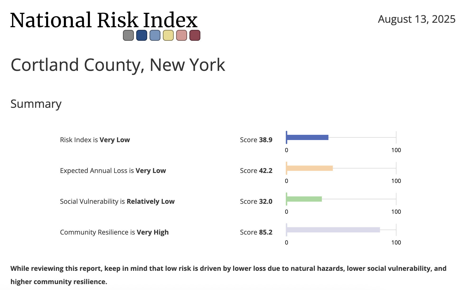
Cortland County ranks 38 out of 62 counties in New York for overall climate vulnerability. This places it in the 28th national vulnerability percentile, indicating a lower overall vulnerability.
Key Vulnerabilities:
The report identifies several key areas where Cortland County has higher vulnerability:
Climate Impacts: The county ranks 14 out of 62 counties in New York for vulnerability to environmental and economic disruptions from climate impacts, placing it in the 60th national vulnerability percentile.
Extreme Events: The county has a very high vulnerability to historical and projected extreme weather event occurrences, ranking in the 93rd national vulnerability percentile.
Precipitation: Vulnerability related to precipitation is also a significant concern, ranking in the 92nd national vulnerability percentile.
Social Stressors: The county shows high vulnerability to social stressors, ranking in the 88th national vulnerability percentile.
Food, Water, and Waste Management: This area is a major concern, ranking in the 78th national vulnerability percentile.
Energy: The county shows a vulnerability to energy factors, ranking in the 70th national vulnerability percentile.
Areas of Relative Resilience
The report also highlights several areas where the community shows lower vulnerability:
Community Baseline: The county ranks 48 out of 62 counties in New York for resilience to climate impacts, placing it in the 23rd national vulnerability percentile, indicating a lower vulnerability.
Health (Community Baseline): Factors reflecting the overall state of population health show low vulnerability, ranking in the 26th national vulnerability percentile.
Infrastructure: Essential structures, services, and resources that affect community resilience show low vulnerability, ranking in the 22nd national vulnerability percentile.
Health (Climate Impacts): Expected changes in community health resulting from a warming climate show low vulnerability, ranking in the 32nd national vulnerability percentile.
Social & Economic (Climate Impacts): The social and economic costs and impacts associated with climate change also show low vulnerability, ranking in the 22nd national vulnerability percentile.
Cortland County has a lower overall climate vulnerability, ranking 38th in New York.
The county's primary vulnerabilities are related to climate impacts such as extreme events and precipitation, and community baseline factors including social stressors and food, water, and waste management.
Areas of resilience include the county's infrastructure, baseline health, and social & economic factors.
Woodstock, Ulster County

Woodstock Livability Stats:
Rural ● $$ ● Schools: B ● Crime: B ● Community Health: Below Average ● Nearby Airport ● Walkability
Woodstock Homes for Sale and Rent
Woodstock is a place where the legendary spirit of the 1960s counterculture still thrives, seamlessly blended with a contemporary artistic and wellness-oriented vibe. Living here means being surrounded by the scenic beauty of the Catskill Mountains, offering abundant opportunities for hiking, exploring waterfalls, and enjoying a vibrant four-season climate. The local economy is significantly driven by arts, entertainment, and recreation, as well as healthcare and social assistance, and professional, scientific, and technical services. While tourism plays a large role, especially in its eclectic downtown, the presence of companies like Ametek Rotron (which specializes in high-performance fans for defense and aviation) also contributes to employment, providing more stable manufacturing jobs within the area.
The village itself is known for its eclectic mix of art galleries, independent boutiques, live music venues, and diverse culinary scene, drawing a creative and open-minded population. The Onteora Central School District serves the Woodstock area, with Woodstock Elementary School consistently receiving positive reviews for its community-oriented approach. For healthcare, residents have access to local clinics and primary care providers, with more extensive medical services available at larger regional hospitals in nearby Kingston, such as HealthAlliance Hospital. New York State also ensures readily available and protected reproductive healthcare options for residents. While it can get busy with tourists, especially on weekends, the underlying community is tight-knit and highly engaged. The cost of living is on the higher side, particularly for real estate (it's approximately 28.7% higher than the national average), but many find the unique atmosphere, unparalleled access to cultural events, and stunning natural surroundings to be a worthwhile trade-off.
Woodstock Climate Stats

Ulster County ranks 8 out of 62 counties in New York for overall climate vulnerability. This places it in the 46th national vulnerability percentile, indicating an average vulnerability.
Key Vulnerabilities
The report identifies several key areas where Ulster County has higher vulnerability:
Extreme Events: The county has a very high vulnerability to historical and projected extreme weather event occurrences, ranking in the 98th national vulnerability percentile.
Flooding: Flooding is a significant concern, with the county ranking in the 98th national vulnerability percentile.
Precipitation: Vulnerability related to precipitation is high, ranking in the 91st national vulnerability percentile.
Minority Status & Language: The vulnerability related to minority status and language is high, ranking in the 90th national vulnerability percentile.
Social Stressors: The county shows high vulnerability to social stressors, ranking in the 94th national vulnerability percentile.
Transportation: Vulnerability related to transportation is high, ranking in the 87th national vulnerability percentile.
Pollution Sources: The county shows high vulnerability from pollution sources, ranking in the 85th national vulnerability percentile.
Climate Impacts: The county ranks 4 out of 62 counties in New York for vulnerability to environmental and economic disruptions from climate impacts, placing it in the 69th national vulnerability percentile.
Areas of Relative Resilience
The report also highlights several areas where the community shows lower vulnerability:
Community Baseline: The county ranks 20 out of 62 counties in New York for resilience to climate impacts, placing it in the 38th national vulnerability percentile.
Health (Community Baseline): Factors reflecting the overall state of population health show low vulnerability, ranking in the 30th national vulnerability percentile.
Social & Economic (Climate Impacts): The social and economic costs and impacts associated with climate change also show low vulnerability, ranking in the 22nd national vulnerability percentile.
Infrastructure: Essential structures, services, and resources that affect community resilience show low vulnerability, ranking in the 25th national vulnerability percentile.
Health (Climate Impacts): Expected changes in community health resulting from a warming climate show low vulnerability, ranking in the 35th national vulnerability percentile.
Ulster County has an average overall climate vulnerability, ranking 8th out of 62 counties in New York.
The county's primary vulnerabilities are related to climate impacts such as extreme events, flooding, and precipitation, as well as community baseline factors like minority status & language and social stressors.
Areas of resilience include the county's infrastructure, baseline health, and social & economic factors.
We have put together a comprehensive guide for New York that includes:
Modeling data about climate risks, vulnerabilities, and strengths;
Political Context and Competitiveness;
Community Overview of the Region and Neighborhoods;
Economic Opportunity and Cost of Living; diversified economy with growing opportunities;
Schools and Education;
Civic Engagement Opportunities, including political, community and advocacy organizations.
Complete the form below to access everything the New York Guide has to offer.
By sharing your email address, you agree to receive marketing emails from PowerMoves.
By providing your cell phone number, you have provided us with consent to send you text messages in conjunction with the services you have requested. Message & Data Rates May Apply. Text HELP for Info. Text STOP to opt out. No purchase necessary.
Why New York Represents the Future
New York embodies the kind of place where you can find some stability in a changing environment.
The climate is less vulnerable than much of the country.
Your vote genuinely matters in one of the nation's most competitive districts
Your voice can influence policy through accessible local government and civic engagement
Your life can flourish with affordable living, economic opportunity, and community connection
Your presence helps build the inclusive, competitive democracy we all need
This isn't just a place to find refuge—it's a place to build the future.