

We’ve identified communities where you will be safe and welcome and where your vote will be a game-changer at the ballot box.Maine: The Way Life Should Be

Maine: Congressional District 2
Maine’s Congressional District 2 encompasses the vast majority of Maine’s land area, including thousands of miles of coastal area and tidal areas, as well as state and national parks, forests and mountains. The region is also home to Lowest and Lower Climate Risk Vulnerability areas as diverse as Bar Harbor, Bangor and Orono.
Living in central and northern Maine offers a distinctive lifestyle rooted in nature and community. This vast region, defined by forests and lakes, provides a quality of life centered on unparalleled outdoor recreation—from hunting and fishing to snowmobiling and hiking. Communities are tight-knit, with neighbors often supporting one another. While winters are long and harsh, residents embrace the season with a resilient spirit.
Affordability is a key draw, with a lower cost of living, especially for housing, compared to southern Maine. The economy relies heavily on natural resources like forestry and agriculture, alongside growing tourism focused on outdoor adventure. While job diversity may be less than in urban areas, opportunities exist in trades and traditional industries. Schools are typically smaller, offering intimate learning environments. This region appeals to those seeking a quiet, unhurried existence deeply connected to the land and a supportive community.
Much of this district includes areas designated Lower and Lowest Vulnerability on the US Climate Vulnerability Index.
COMMUNITY SNAPSHOTS

Hampden, Penobscot County
Hampden Livability Stats:
Suburban ● $$ ● Schools: A ● Crime: A ● Community Health: Average ● Airport: 30 - 60 Minutes
Hampden Homes for Sale and Rent
Hampden strikes a balance, offering a welcoming atmosphere while providing a high quality of life for its residents. Located in Penobscot County, it is often highlighted for its highly-rated public schools and is considered one of the best places to live in Maine. The town's atmosphere combines a rural feel with the convenience of being close to urban amenities, and a significant portion of its residents are young professionals.
The local economy is diverse and thriving, with major employment sectors including healthcare, retail trade, and educational services. Hampden also boasts a high median household income, significantly above the state average, and a low unemployment rate. The community is served by Regional School Unit #22 (RSU 22), which includes Hampden Academy for grades 9-12, along with other schools for younger students.
The town provides ample opportunities for recreation through the Hampden Recreation Department and the Lura Hoit Memorial Pool. The department offers a wide array of programs and activities for all ages, including various sports, swimming lessons, and special events like Concerts in the Park and the Hampden Fall Festival. Its proximity to the city of Bangor, along with Maine's abundant natural beauty, offers residents the best of both a close-knit community and regional access.
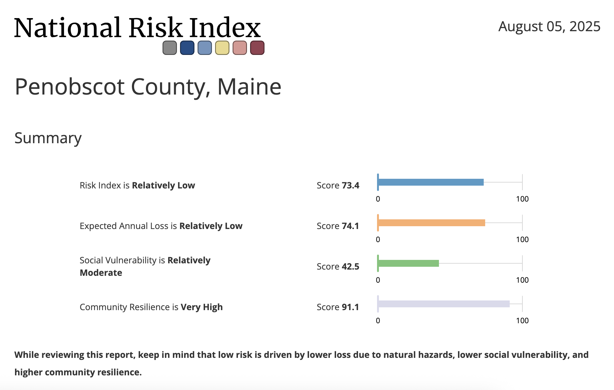
Hampden Climate Stats
Hampden faces significant climate vulnerabilities, particularly from extreme weather events and flooding. However, it also demonstrates relative strengths in other areas, contributing to a more nuanced picture of its overall resilience.
Key Vulnerabilities:
Extreme Events: The county has a very high vulnerability to historical and projected extreme weather events, ranking in the 99th national vulnerability percentile.
Flooding: Flooding is a major vulnerability, with the county ranking 3rd out of 16 counties in Maine and in the 97th national vulnerability percentile.
Social Stressors: Social stressors related to climate impacts are a significant vulnerability, ranking in the 99th national vulnerability percentile and 6th in Maine.
Land Use: The county has a high vulnerability related to land use, ranking in the 95th national vulnerability percentile and 2nd in Maine.
Areas of Relative Resilience:
Overall Vulnerability: Penobscot County has a low overall climate vulnerability compared to other areas, ranking 2nd out of 16 counties in Maine with a 39th national vulnerability percentile.
Health: The expected changes in community health resulting from a warming climate are a major strength, with the county ranking in the 2nd national vulnerability percentile for this factor.
Infrastructure: The county's essential structures, services, and resources show a low vulnerability, ranking in the 16th national vulnerability percentile.
Social & Economic: The county has a lower vulnerability to social and economic costs and impacts associated with climate change, ranking in the 38th national vulnerability percentile.
Community Baseline: Penobscot County has a lower vulnerability for its community baseline, ranking 4th out of 16 counties in Maine with a 35th national vulnerability percentile.

Bar Harbor, Hancock County
Bar Harbor Livability Stats:
Suburb ● $$/$$$ ● Schools: A ● Crime: A ● Community Health: Above Average ● Nearby Airport ● Walkable
Bar Harbor Homes for Sale and Rent
Living in Bar Harbor offers a quintessential coastal New England experience, marked by stunning natural beauty as it borders Acadia National Park, and a bustling, tourist-driven summer season. Year-round residents enjoy unparalleled access to hiking, biking, and ocean activities, but must adapt to a quieter "off-season" when many businesses close and the town's population significantly dwindles, alongside the challenge of finding affordable year-round housing. Tremont located on the "quiet side" of Mount Desert Island, provides a more rural and traditionally maritime lifestyle, with a focus on fishing, boat building, and a slower pace, appealing to those seeking tranquility away from the summer crowds.
Bar Harbor Climate Stats

Bar Harbor, as part of Hancock County, faces significant climate vulnerabilities, particularly from social stressors, flooding, and precipitation-related issues. However, it also demonstrates relative strengths in other areas, contributing to a more nuanced picture of its overall resilience.
Key Vulnerabilities:
Social Stressors: The county's vulnerability to social stressors related to climate impacts is very high, ranking in the 97th national percentile and 15th out of 16 counties in Maine.
Flooding: Flooding is a significant vulnerability, with the county ranking in the 95th national percentile and 6th in Maine.
Precipitation: Vulnerability to precipitation ranks in the 87th national percentile and 15th in Maine.
Energy: The county shows high vulnerability related to energy, ranking in the 83rd national percentile and 3rd in Maine.
Extreme Events: Historical and projected extreme weather event occurrences are a notable vulnerability, ranking in the 97th national percentile.
Areas of Relative Resilience:
Overall Vulnerability: Hancock County has a low overall climate vulnerability compared to other areas, ranking 15th out of 16 counties in Maine with a 13th national vulnerability percentile (lowest vulnerability).
Health: Factors reflecting the baseline state of population health show low vulnerability, ranking in the 30th national percentile. Expected changes in community health resulting from a warming climate are also a major strength, ranking in the 3rd national vulnerability percentile.
Environment: Environmental factors that pose a threat to community well-being show very low vulnerability, ranking in the 5th national vulnerability percentile.
Social & Economic (Community Baseline): Social and economic stressors that impact community resilience are relatively low, ranking in the 21st national vulnerability percentile.
Infrastructure: Essential structures, services, and resources that affect community resilience show low vulnerability, ranking in the 11th national vulnerability percentile.

Augusta, Kennebec County
Augusta Livability Stats:
Suburban ● $$ ● Schools: B ● Crime: C ● Community Health: Above Average ● Nearby Airport
Augusta Homes for Sale and Rent
Augusta provides a charming blend of historical character and natural beauty, serving as both the state capital and a welcoming community. Situated on the Kennebec River, residents enjoy a range of outdoor activities, including boating and fishing, along with access to local parks and historic sites like the Old Fort Western.
Augusta's economy is stable and primarily driven by its role as the state capital, with a significant portion of the workforce employed in government administration, healthcare, and education. Major employers include the State of Maine, MaineGeneral Health, and the University of Maine at Augusta. The city's strategic location in central Maine also supports a robust service sector and small businesses.
The city is part of the Augusta School Department, which oversees local public schools and offers educational programs for students from pre-K through high school. Healthcare is a cornerstone of the community, with MaineGeneral Medical Center serving as a major regional hospital, providing comprehensive medical services and specialized care. This strong infrastructure, combined with a close-knit community feel and a rich historical background, makes Augusta a great place to live and work.

Augusta Climate Stats
Augusta, in Kennebec County, faces significant climate vulnerabilities, primarily from extreme weather events, inland flooding, and warmer temperatures. However, the city and state are actively working on resilience and mitigation, contributing to a more nuanced picture of its overall resilience.
Key Vulnerabilities:
Inland Flooding: Augusta and other communities along the Kennebec River have experienced major flooding, with ice jams and heavy rains causing damage. The December 2023 flooding event is noted as an example of how extreme weather patterns will likely become more severe with climate change.
Extreme Weather Events: Maine's climate is getting warmer and wetter, with more high-intensity rainstorms. This is expected to increase the intensity of storms, particularly with the amount of precipitation they produce.
Warmer Temperatures: Temperatures are projected to increase by 2–4°F by 2050, leading to more frequent heatwaves and a longer growing season, which may also be offset by increased evaporation and soil moisture deficits.
Social Vulnerability: Across Maine, some populations, including rural, older, and lower-income residents, are particularly vulnerable to climate change impacts.
Areas of Relative Resilience:
Infrastructure Adaptation: MaineDOT is conducting a statewide climate vulnerability assessment to address risks to transportation infrastructure. The state's four-year climate action plan, "Maine Won't Wait," recommends assessing climate vulnerability and providing climate-ready design guidance.
Community Planning: The city of Augusta is actively participating in the Community Resilience Partnership, a program that provides resources and technical assistance to help address climate change and resilience goals. The city is also hosting public workshops to gather input on its climate action priorities.
Statewide Initiatives: The state of Maine has a proactive climate action plan, "Maine Won't Wait," which includes goals for reducing emissions, preparing for impacts, and strengthening communities. This plan provides a framework for statewide action on climate change.

Orono, Penobscot County
Orono Livability Stats:
Suburban ● $$ ● Schools: B ● Crime: B ● Community Health: Average
Living in Orono offers a peaceful and scenic small-town atmosphere with the advantage of being close to the University of Maine. The town is surrounded by beautiful forests and is near the Penobscot River, making it ideal for outdoor enthusiasts who enjoy hiking, kayaking, and exploring nature. Orono has a tight-knit community with a mix of students, faculty, and locals. The University of Maine serves as a central pillar of the local economy and is the region's largest employer, while students are served by the Orono School Department. The winters can be cold and snowy, but the charming downtown area provides cozy cafes, shops, and a variety of cultural activities thanks to the university. Overall, it’s a quiet yet vibrant place to call home.
Orono Climate Stats

Penobscot County, which is where Orono is situated, faces significant climate vulnerabilities, particularly from extreme weather events and flooding. However, it also demonstrates relative strengths in other areas, contributing to a more nuanced picture of its overall resilience.
Key Vulnerabilities:
Extreme Events: The county has a very high vulnerability to historical and projected extreme weather events, ranking in the 99th national vulnerability percentile.
Flooding: Flooding is a major vulnerability, with the county ranking 3rd out of 16 counties in Maine and in the 97th national vulnerability percentile.
Social Stressors: Social stressors related to climate impacts are a significant vulnerability, ranking in the 99th national vulnerability percentile and 6th in Maine.
Land Use: The county has a high vulnerability related to land use, ranking in the 95th national vulnerability percentile and 2nd in Maine.
Areas of Relative Resilience:
Overall Vulnerability: Penobscot County has a low overall climate vulnerability compared to other areas, ranking 2nd out of 16 counties in Maine with a 39th national vulnerability percentile.
Health: The expected changes in community health resulting from a warming climate are a major strength, with the county ranking in the 2nd national vulnerability percentile for this factor.
Infrastructure: The county's essential structures, services, and resources show a low vulnerability, ranking in the 16th national vulnerability percentile.
Social & Economic: The county has a lower vulnerability to social and economic costs and impacts associated with climate change, ranking in the 38th national vulnerability percentile.
Community Baseline: Penobscot County has a lower vulnerability for its community baseline, ranking 4th out of 16 counties in Maine with a 35th national vulnerability percentile.
We have put together a comprehensive guide for Maine that includes:
Modeling data about climate risks, vulnerabilities, and strengths;
Political Context and Competitiveness;
Community Overview of the Region and Neighborhoods;
Economic Opportunity and Cost of Living; diversified economy with growing opportunities;
Schools and Education;
Civic Engagement Opportunities, including political, community and advocacy organizations.
Complete the form below to access everything the Maine Guide has to offer.
By sharing your email address, you agree to receive marketing emails from PowerMoves.
By providing your cell phone number, you have provided us with consent to send you text messages in conjunction with the services you have requested. Message & Data Rates May Apply. Text HELP for Info. Text STOP to opt out. No purchase necessary.
Why ME-02 Represents the Future
Maine's 2nd Congressional District embodies the kind of place where you can find some stability in a changing environment.
The climate is less vulnerable than much of the country.
Your vote genuinely matters in one of the nation's most competitive districts
Your voice can influence policy through accessible local government and civic engagement
Your life can flourish with affordable living, economic opportunity, and community connection
Your presence helps build the inclusive, competitive democracy we all need
This isn't just a place to find refuge—it's a place to build the future.